
Campus for the Research and Development of Land Production
The periphery of large urban centers have long been the site for activities and uses that benefit from seclusion—namely industry, waste infrastructure, leisure, and recreation. Jamaica bay, on the southeastern outskirts of New York City, is a site of all such uses. Its beaches and the islands have historically been used recreationally by New Yorkers, however it was not until after the bay was rejected as a location for the port of New York in the early 20th Century that the islands and coastal area were was zoned and developed as parks. The prolific Robert Moses established the park in the 1940s in the same rezoning plan in which he put in the four wastewater treatment plants, placed New York City Public Housing Projects in the far rockaways, and artificially constructed two freshwater ponds on Broad Channel Island before naming the area the Jamaica Bay Wildlife Refuge. (It is technically not recognized or operated as a Wildlife Refuge by the National Parks Department). In 1972 Jamaica Bay and its islands, along with areas in Sandy Hook and Staten Island, were inaugurated as the Gateway National Recreation Area.

Over the last hundred years, large scale infrastructural developments in Jamaica Bay have drastically changed the shape and size of its coast and islands. Some of this change was designed, most was unintended. The shore of the bay is host to familiar municipal infrastructures necessary for the maintenance of a contemporary American city—it is dotted with four wastewater treatment plants, three closed city landfills, and an international airport. The vast impermeable surfaces of the airport runways inevitably direct toxic storm water run-off into the bay. The landfills along the water's edge slowly leach toxins while the wastewater treatment plants release partially treated wastewater rich in nitrogen into the bay daily. The effects of these contaminants are then exacerbated by the warming of the water due to the global effects of climate change (to which these contribute.) The warm nitrogen rich water erodes the islands and the coast. Sea level rise is experienced bimonthly by the residents of Broad Channel Island, the only inhabited island in the bay, when tidal flooding submerges their streets. The residents of the Rockaways and of Broad Channel Island have faced destruction of property and mandatory evacuations during both hurricane Irene in 2011 and hurricane Sandy in 2012.
The large scale and accelerated erosion of the islands is currently being combated by the National Park Service who have since 2006, partnered with the United States Army Corps of Engineers (USACE) and local non-governmental organizations to reconstruct approximately 154 acres of salt marsh islands using the dredged material from maintenance and deepening operations of the shipping channels that access the New York and New Jersey Harbors.


The depths of the shipping channel in the New York Harbor need to be maintained in order to accommodate large shipping barges. The deeper a shipping barge can be submerged in the channel, the more cargo it can carry and thus the greater economic value the entire shipment will have. Constant maintenance of these channels are needed due to sediment build up from both the natural flows of hudson river estuary and from the dominant incoming sea swell and littoral drifts from the Atlantic Ocean along the Long Island and New Jersey Coasts. The necessary logistics of removing sediment to maintain the large scale commercial infrastructure of the ports enables the National Park Service in partnership with the USACE to reconstruct nature as a cultural and recreation resource by repurposing this waste sediment. Leachate and nitrogen rich wastewater from the municipal waste infrastructures unceasingly flow into the bay and persistently erode the land while the waste material from the maintenance of the commercial maritime infrastructure aids to the reconstruction of it. These unintended byproducts and effects of each municipal process do not negate the effects of each other, but rather serve as two outputs that demand a cyclical process of reconstruction of the ‘natural environment’ in which nature will continue to be redefined by the urban systems that are enabling their re-production.
Jamaica Bay has the ideal features to serve as a field campus and site for the Army Corp of Engineers. The focus of this organization on the techno-bureaucratic management of land makes this site germane for a school and lab to study and test new climatic conditions, water compositions, and waste landforms. The area will remain a National Recreation Area, open to the public, and accessible for current residents to continue to live within the bounds of the campus.

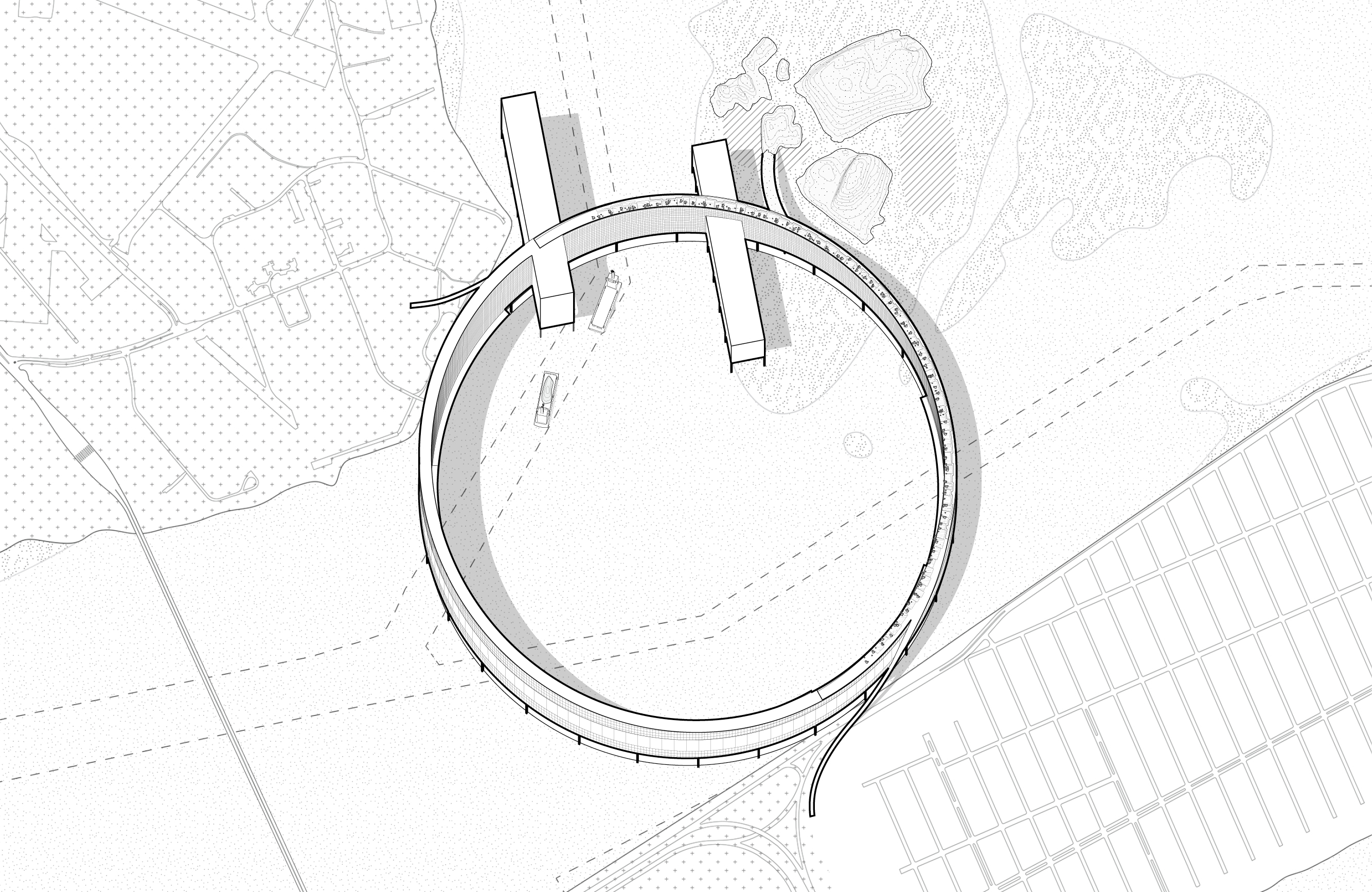
The Center For Contaminated Sediment
This center serves as the gate to the entire campus. It is located at the only inlet into Jamaica Bay. This building has multiple functions: it serves as a foot and bicycle bridge connecting two parks within the National recreation areas—Barren Island and Fort Tilden; It processes toxic sediment dredged from the Ambrose Channel, biosolids remnants from the wastewater treatment plants dotting the bay, and recovered material from the fountain avenue and pennsylvania avenue landfills; lastly it acts as a flood gate at the inlet to Jamaica bay, which aids in managing the water level of the bay to perform controlled experiments within the entire bay as well as within the open area at the center of the circular building.


The Institute for Nature Reconstruction
This Institute serves as both a continuation of the trail system starting on Broad Channel island as well as a scaffold for engineers working to reconstruct the wetlands. Civilian access is restricted to these wetlands due to the fragility of the environment and the toxicity of the water. Now visitors to the recreation area can become immersed in the wetlands without disturbing it.


The School of Urban Infrastructure and Environmental Change
The School of Urban Infrastructure and Environmental Change monitors and studies the effects of sea level rise, warmer waters, increased weather events, and increased nitrogen in water on urban infrastructure, such as subway lines, bridges, docks, streets, stop lights, etc.


The Center for Contaminant Hydrology
This center features a large square frame with twenty-nine underwater laboratories simultaneously and continually testing water at slightly different depths in order to identify both speed of water flow and level of toxicity. There are two of these floating centers: one located near the outlet from the canal to the north of JFK international airport where one of the four wastewater treatment plants lining Jamaica bay outputs its wastewater; and one roaming the waters near the deepest part of the bay, just west of the runways for the airport.


The School of Neo-geology and Landfill Mining
The mission of this school is to create and codify procedures for recovering useful materials from within landfills currently expelling natural gas into the atmosphere. Not only will this school attempt to rediscover valuable resources that are buried in the ground but to understand settling methods of the new geological typology—city landfill.

